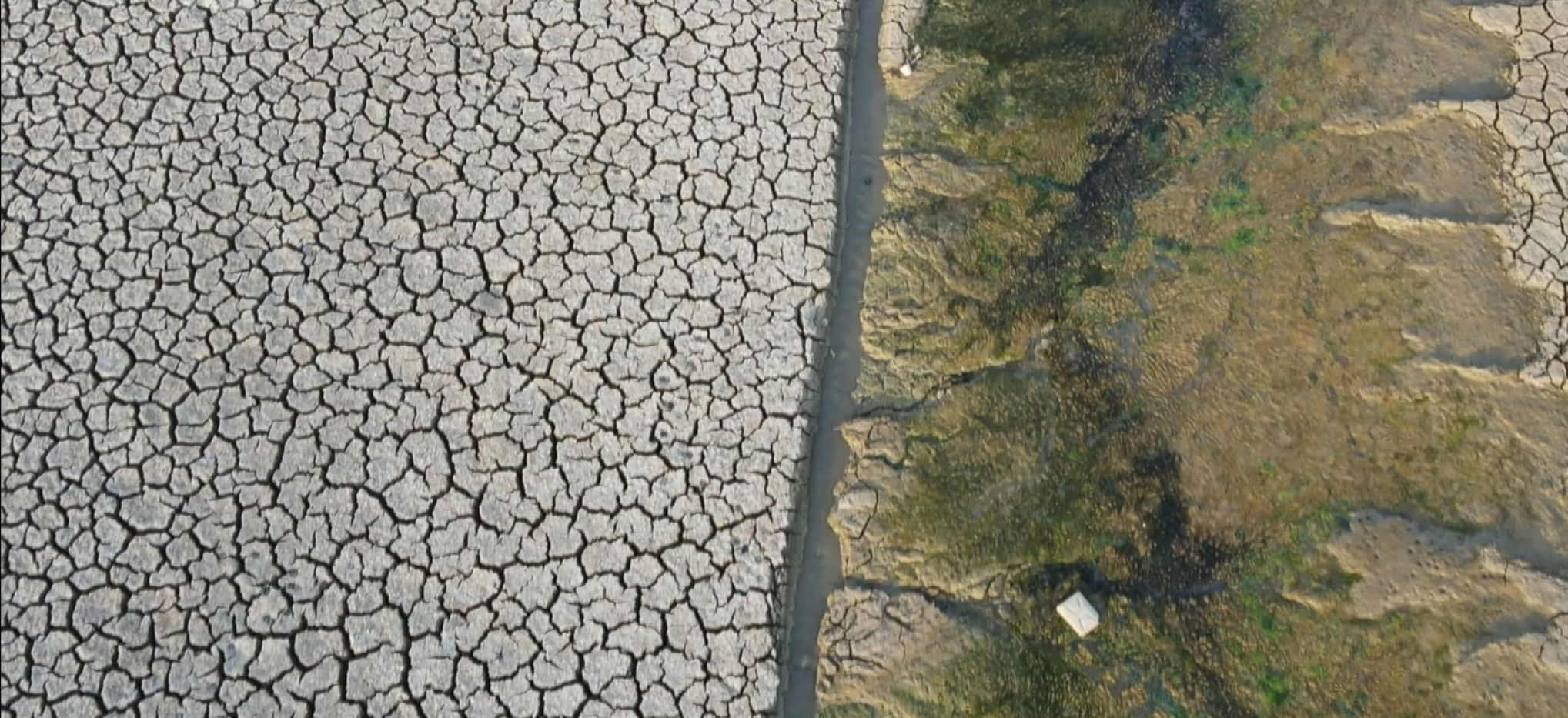


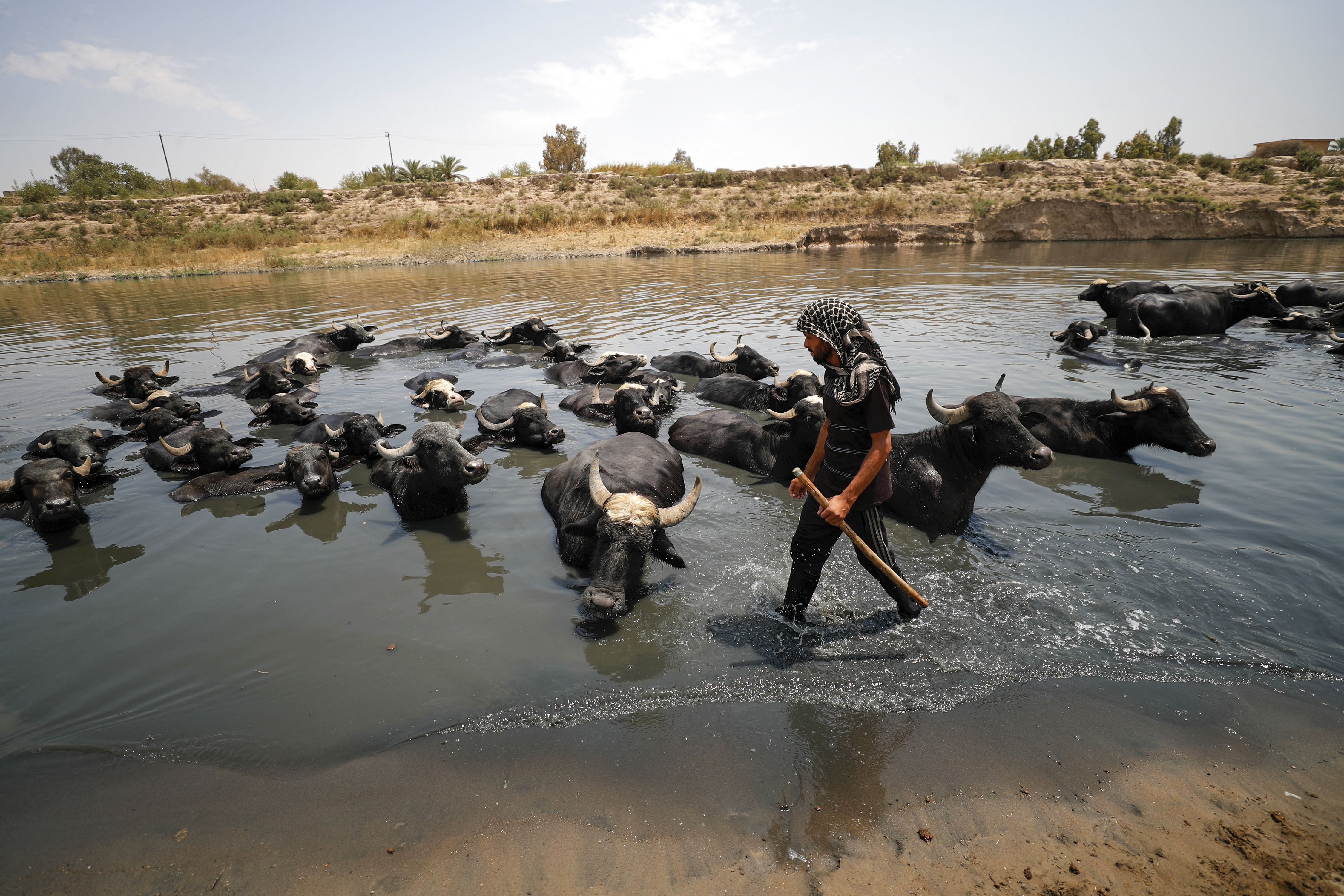
The summer of 2021 witnessed how water security is at the core of the debate on the climate crisis in Iraq. The lack of rain left a trail of social and economic despair in the agricultural areas, as harvests failed, instilling fear and uncertainty in farming communities on what the future may hold. Iraqi citizens expressed concerns on social media by sharing photos of lakes and rivers running dry, and taking protests to the streets over water shortages. Current estimates by the government is that over 50 % of all crops were lost. For example, in Ninewa Plain, the estimated losses in agriculture is over 70% due to the drought. Humanitarian organizations warned that over 7 million people in Iraq will be affected by the water crisis as lack of water impacts on fishing farms, hydropower and drinking water. UN organisations have been performing detailed assessments on food and water security and the rising social tensions of water resources, in particular in the south of Iraq.
In the broader discussion over environmental and climate security in Iraq, water often is put on the forefront. The country suffers from decades of conflict that damaged environmental infrastructure and where collapse of environmental governance worsened existing problems around managing water sources, where in particular water harvesting is key for irrigations. In particular, dealing with sustainable agricultural practices, treatment of wastewater, the decline of the Iraqi Marshes, a unique and protected wetland area, and severe pollution of its rivers is a major challenge for the Iraqi government. As temperatures skyrocket in the summer and rain patterns become unpredictable, the climate impacts are felt deeper into the fibers of Iraq’s society, already driving people away from rural areas to the cities, creating tensions between groups. These compounding impacts are turning the country into a climate security hotspot, with long-term implications on socio-economic, humanitarian and ecological conditions. Ongoing concerns have been flagged not only in multiple media report, but also by civil society organisations in multilateral forums such as the UN Human Rights Council and became part of the UN Security Council Resolution 2576 that called for taking meaningful actions to adtop challenges by climate change and ecological change.
Visualizing Water Decrease from Space
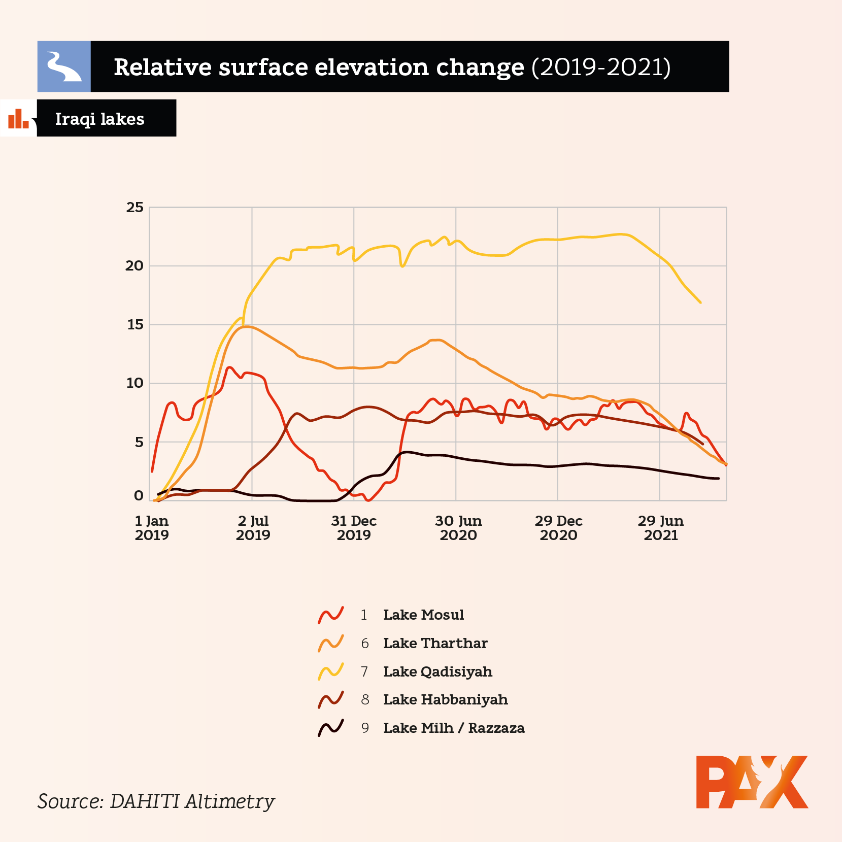
To better understand the magnitude of the drought and water scarcity, we analyzed the water decrease in twelve major lakes and water reservoirs in Iraq. Using the European Space Agency’s Sentinel-2 LC1 optical imagery accessed through Earth Engine and altimetry data from the DAHITI database for 5 lakes we mapped the decrease of water extent and water level in the period September 2020-2021, showing significant decrease in volume in various water bodies. Though this is just a 1 year snapshot, with previous years witnessing an increase due to heavy rain in winter, this visualization aims to show the severity of the hydrological drought in key areas which had lack of water influx. A full overview with all relevant data can be accessed here.
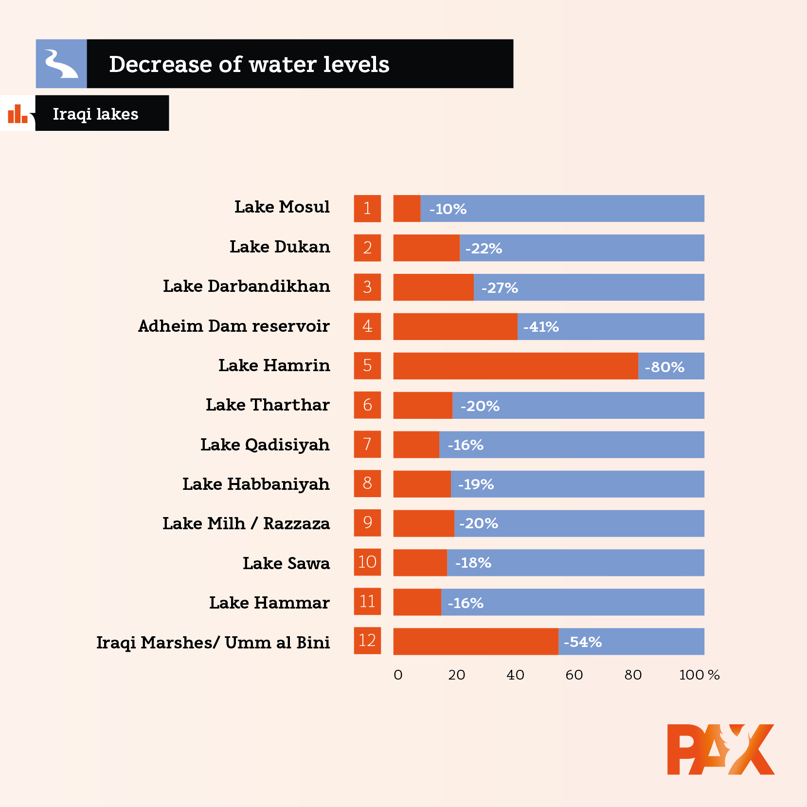
In the figure above, the ‘current’ water extent can be seen for the studied water bodies at the end of September 2021. In the left part, their proportions can be compared, for example Lake Qadisiyah is by far the largest and Sawa lake the smallest (barely visible). Their areas (ha) are specified in the right part, here we can also see the water extent loss percentage from 2020 to 2021. For example, in one year the Adheim Dam reservoir lost 80% of its water surface extent from the end of September 2020, ending up with 2,828 hectares by the end of September 2021. The ‘current’ extent is 20% of the surface area it had one year before. In the graphic below, the altimetry data from five lakes shows the fluctuating levels over the last three years, with a decrease in 2021. This data was used as with certain water reservoirs, the water level drop is better measurable using altimetry data rather than size of the lakes.
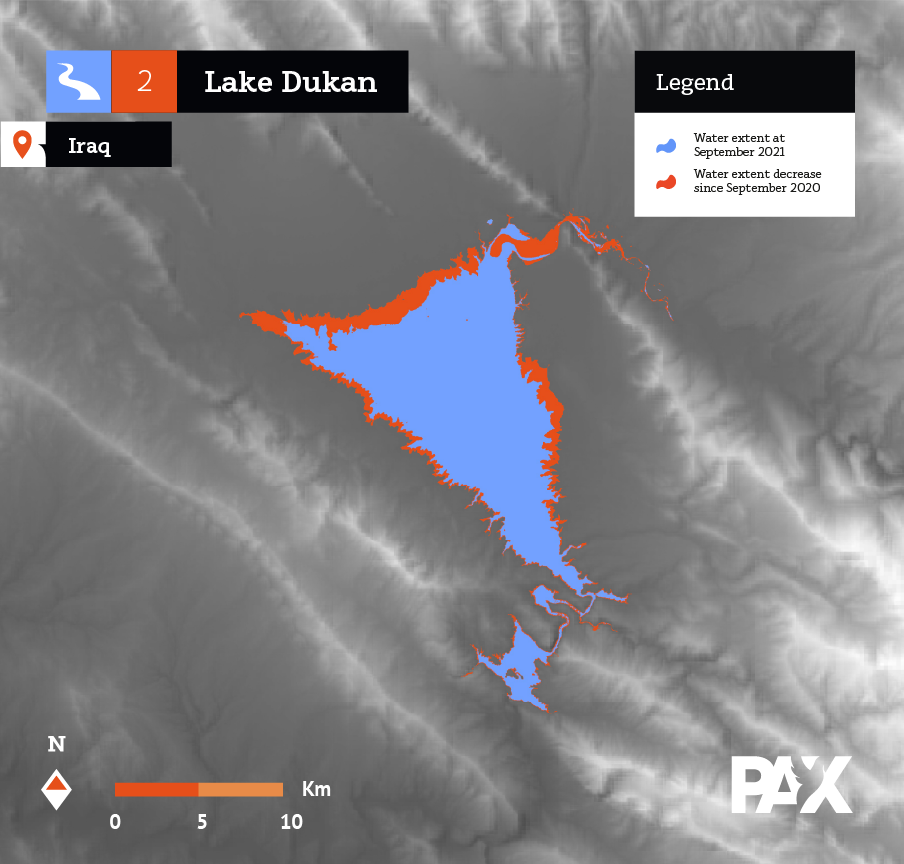
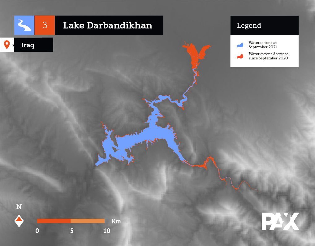
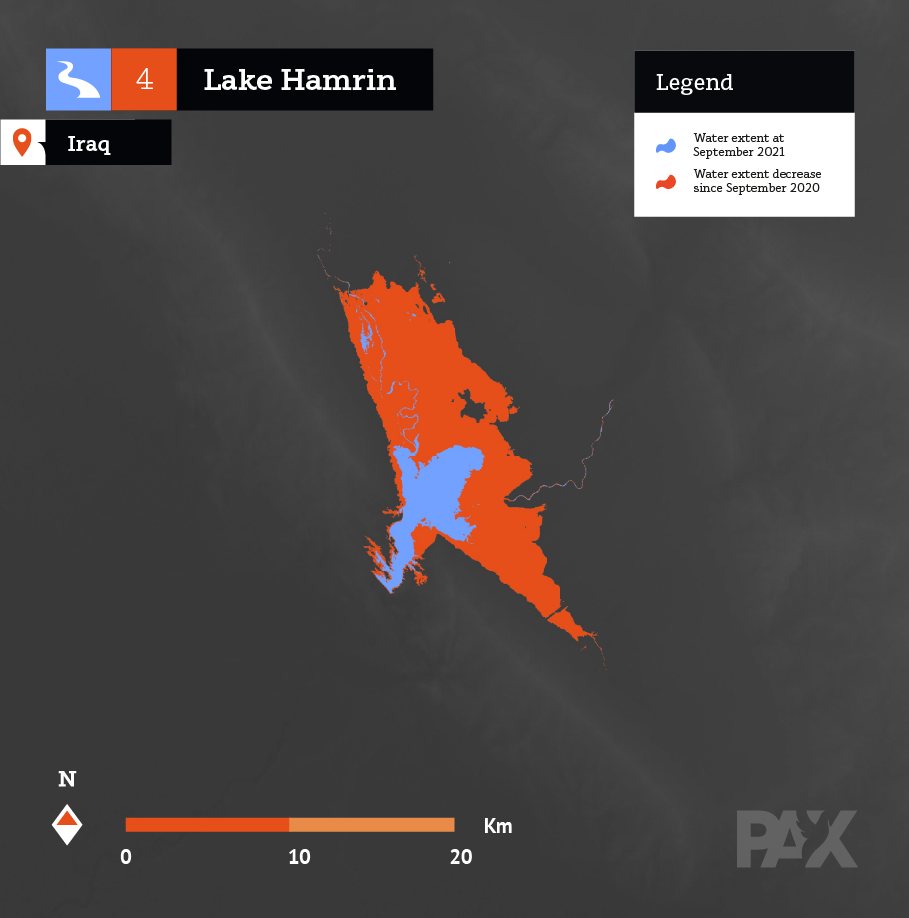
Despite the natural fluctuations in water levels in some lakes and reservoirs, there is a particular decrease visible in the Hamrin Lake, Iraqi Marshes, Lake Dukan and the northern parts of Lake Darbandikhan, which seems to have suffered the most from the absence of rainfall and subsequent drought, some of that could be linked with an increase cross-border water retention that prevent the lakes from filling.
<photo>
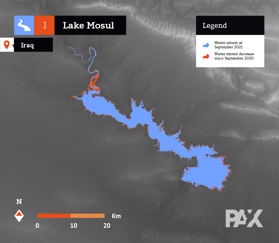
Lake Mosul
The largest dam lake in Iraq, constructed in the early 1980’s by Saddam Hussein and is located in the Nineveh governorate. The lake is the source of hydro electricity and irrigation water for downstream farming. The Mosul lake is part of the Tigris river system. There are existing concerns over its structures as it requires frequent maintenance.
Lake Dukan
Located in the Kurdistan Region of Iraq, the reservoir is part of the Little Zab or ‘ Al Zab Al Saghir’ river. It was built in the late 1950’s to provide hydro-electricity and water for irrigation. The lowering water levels are feared to result in more tensions over acces, as farmers struggle for survival.
Lake Darbandikhan
Another large hydroelectricity dam which was built in the 1950’s in Iraqi Kurdistan to create a water reservoir and support irrigation flows downstream. Some part of the dam required significant repairs after the various armed conflicts in the Iran-Iraq war, bombings in the 1990 and sustained neglect, while also struggling with various pollution sources. The water lows now are the lowest recorded in 65 years.
Lake Hamrin
This 2 billion m3 water reservoir was built in the 1980s for irrigation in Iraq’s agricultural rich Diyala governorate. Newly constructed dams in Iran lead to an alarming decrease of its water influx limiting water availability in 2008. The reservoir is facing increased depletion of water levels since 2019, also impacting the Diyala river and agricultural areas depending on it.
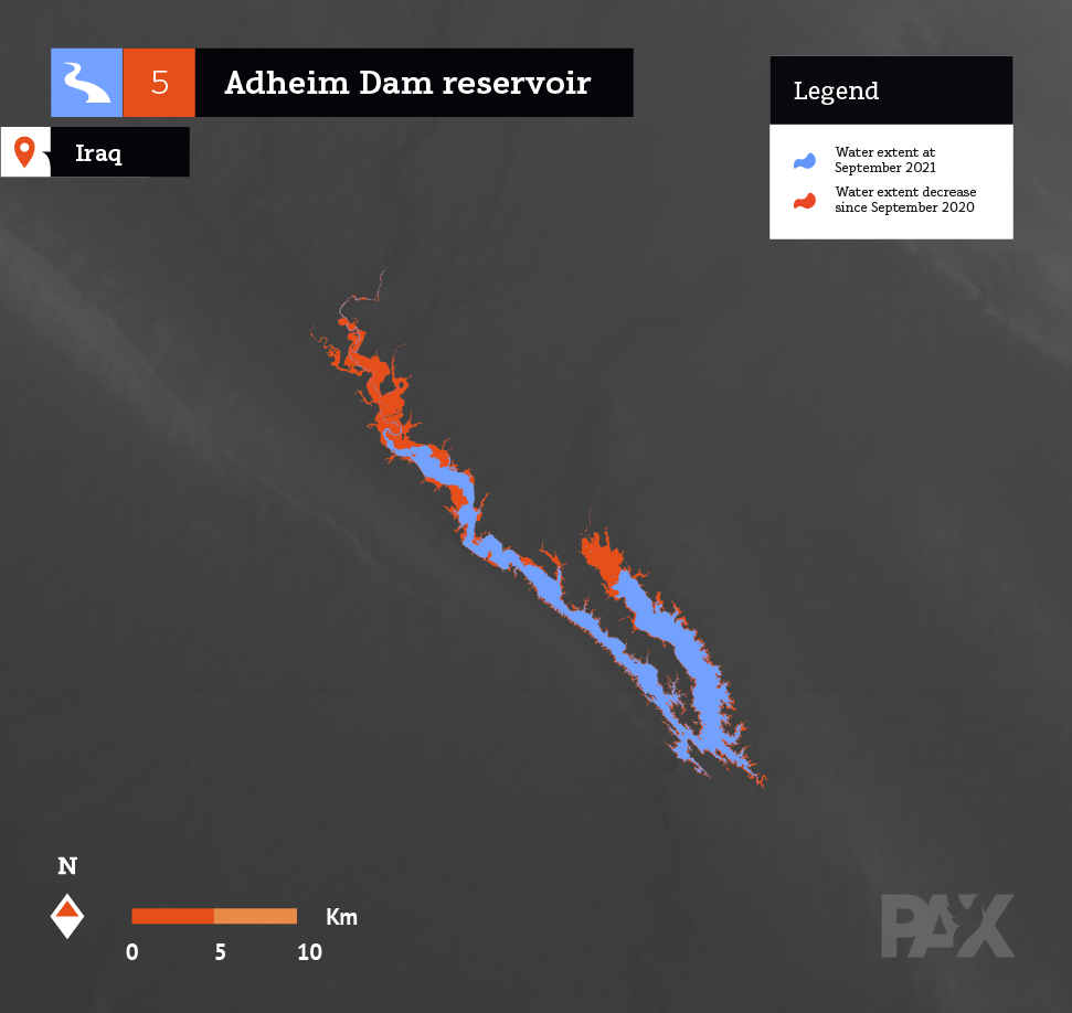
Adheim Dam Reservoir
Built in 2000 in the Salaheddin governorate in central Iraq, the dam was constructed for flood control, hydropower and irrigation, yet still not completed.
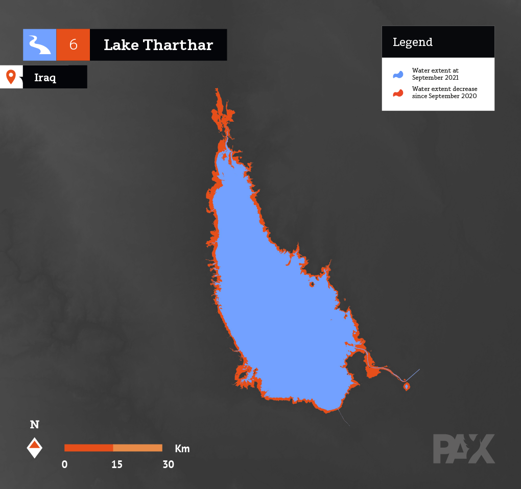
Lake Thartar
An artificial lake constructed in 1950’s located between the Tigris and Euphrates in the Anbar province. The lake is used to collect water during the flooding season and retain it for irrigation in the dry season.
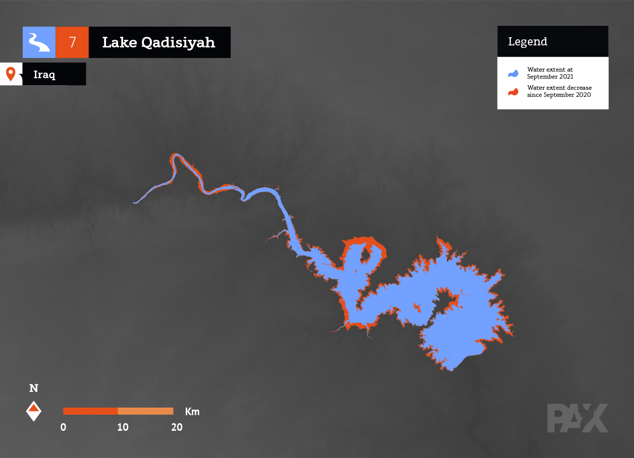
Lake Qadisiyah
This reservoir was constructed by building a dam in the Euphrates river in Al Anbar governorate at the town of Haditha, providing water for irrigation.
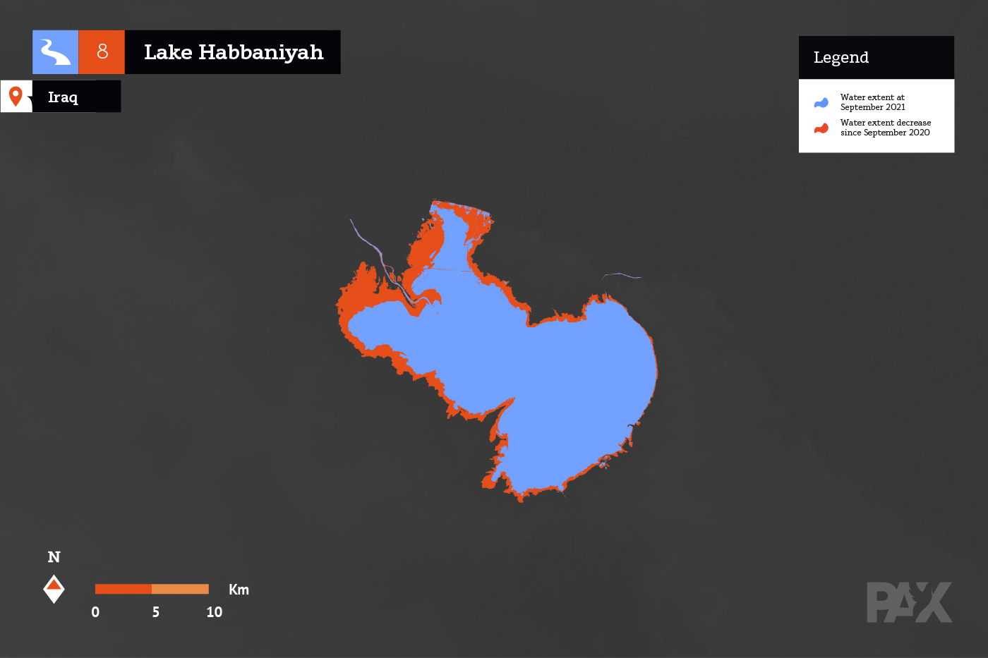
Lake Habbaniyah
A natural lake in Anbar province, west of Baghdad that was known as an important tourist area. The lake faced a severe water shortage in the period 2014-2018 but bounced back after heavy rainfall in the winter period between 2019 and 2020.
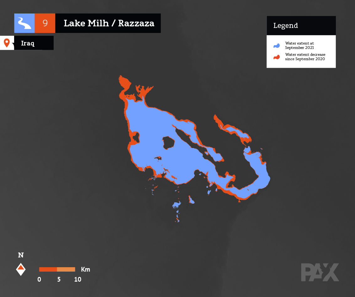
Lake Razzaza
Also known as Lake Milh, this major artificial water reservoir was constructed in the 1970s to capture excess water from the Habbaniyah lake. It is host to rich biodiversity that is rapidly declining due decrease of water levels and salinization.
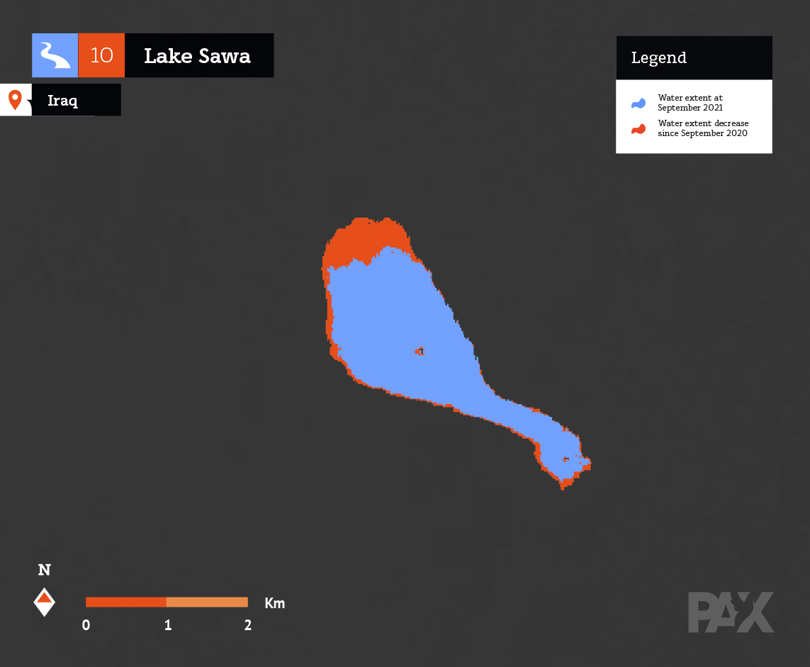
Lake Sawa
This lake has a unique feature having very high salinity state or conditions It feeds from water coming in from cracks in the ground, percolating from the Euphrates river. The evaporation rates in the summer make it shrink substantially between seasons. The summer of 2021 was particularly heavy, making the lake almost disappear, yet a later water influx in August compensated for the initial loss.
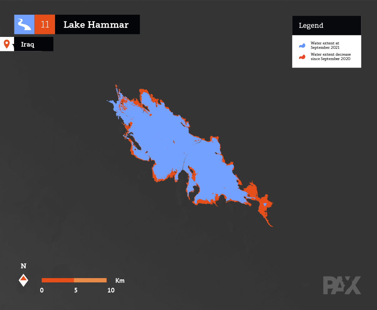
Lake Hammar
Part of the UNESCO protected Iraqi Marshes, this lake with seasonal fluctuating water levels is an important biodiversity area and host of the native Marsh Arabs. It is the largest lake in the lower Euphrates.
In 1992 there were dike works visible to dam this low lying area which presented shallow seasonal floods in the winter season from local precipitation. In 1993 between April and May, the dam was filled from the Euphrates river water in several weeks to its maximum level. It remained with these high water levels until 1998 when it went completely dry. Around 2003/2004 it was filled again but to less than half its original exten. It remains in this similar size until 2021.
Iraqi Marshes / Umm Al Bini
This wetland is a particular case between the studied water bodies. Unlike the others, it does not have much open water surface. Instead it is a large wetland complex, here we only look at the north part of it. The result serves as a preliminary indication of the drying trend in the last year, in stark contrast with increase of water fill prior to 2021, as remote sensing indicated. Additionally, Iraq’s marshes struggle with pollution from oil and gas extraction.

Citizens’ perspective on climate, environment and peace.
With a growing momentum in the Middle East to build regional policies on transboundary water solutions that tackles the climate security challenges from decreasing or irregular water levels, this brief overview aims to contribute to the discussion visualising ecological degradation linked with decreasing water levels. PAX believes in the importance of anticipating climate-linked security challenges through research-based advocacy and engagement with local communities in finding solutions to these environmental security risks. This satellite assessment is helpful in showing the magnitude of the water issues, yet more importantly is to understand what this means for Iraqi people’s lives and livelihoods. Their participation and input is elementary in any meaningful analysis and decision making when building an environment, peace and security strategy for the country’s future.
Thanks to Maha Yassin (@MahaYassin00) at Clingendael for additional feedback in personal capacity. GIS and environmental analysis by Roberto Jamarillo, Graphic Design by Frans van der Vleuten.